Count of Portugal
⏳ Unreviewed position0
daily views
0 total
The County of Portugal (Galician-Portuguese: Condado de Portugal; referred to as Portugalia in contemporary documents) refers to two successive medieval counties in the region around Guimarães and Porto, today corresponding to litoral northern Portugal, within which the identity of the Portuguese people formed. The first county existed from the mid-ninth to the mid-eleventh centuries as a vassalage of the Kingdom of Asturias and the Kingdom of Galicia and also a part of the Kingdom of León, before being abolished as a result of rebellion. A larger entity under the same name was then reestablished in the late 11th century and subsequently elevated by its count in the mid-12th century into an independent Kingdom of Portugal.
Current Images

Main article image

Condado portucalense carte-1070-fr.png
Carte du comté portucalense vers 1070
Carte du comté portucalense vers 1070
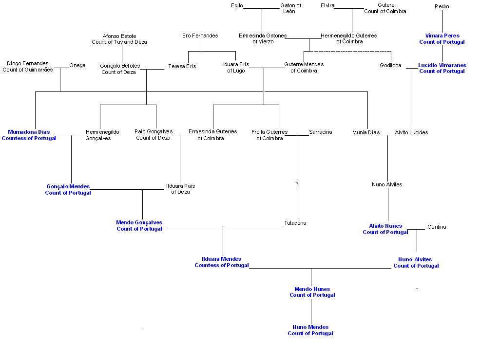
House of Vimara Peres.PNG
Image of the genealogy of the Counts of the First County of Portugal, the so called House of Vímara ...
Image of the genealogy of the Counts of the First County of Portugal, the so called House of Vímara ...

NorthenIberia1126.jpg
Political map of the north part of the Iberic peninsula in the year 1126
Political map of the north part of the Iberic peninsula in the year 1126

PortugueseFlag1095.svg
Flag of Portugal c. 1095 - c. 1143.
Flag of Portugal c. 1095 - c. 1143.

Péninsule ibérique en 1115.png
Carte de la Péninsule ibérique en 1115 illustrant les principaux évènements de l'époque
Carte de la Péninsule ibérique en 1115 illustrant les principaux évènements de l'époque

Péninsule ibérique en 900.png
Carte de la péninsule ibérique de 875 à 900, montrant les principaux évènements de l'époque
Carte de la péninsule ibérique de 875 à 900, montrant les principaux évènements de l'époque

Shield of the County of Portugal (1095-1139).png
Shield of the County of Portugal after D. Henry Burgundy, 1st County of Portugal
Shield of the County of Portugal after D. Henry Burgundy, 1st County of Portugal

Blank.png
Blank picture, 3 x 2 pixels; good for a placeholder when you need it to assume a 3:2 aspect ratio.
Blank picture, 3 x 2 pixels; good for a placeholder when you need it to assume a 3:2 aspect ratio.
Search Openverse for Replacements
Presets: